Once again, it is best if you view this on a computer and not a phone.
Leaving the PNW on April 29th, I missed a turn somewhere and we ended up taking a ferry to Everett, WA, which only cost a few senior-rate dollars and saved us an hour-and-a-half. I love those kinds of mistakes! Deciding on the scenic route, we followed Rt 2 from Everett all the way to Kalispell, MT, near Glacier NP and, from time to time, the road veered far enough north to be close to the Canadian border. We got excited about bumping up in to Canada for part of the trip, then Steve remembered that we had lots of cannabis gummies in the car (they help me fall asleep and stay asleep), and we weren’t going to rent a hotel room to leave them in for one night just to drive in to Canada.
Except for the stretch from Wenatchee, WA to Spokane, WA, Rt 2 is a scenic red road on the atlas (yes, we still carry one). Here and there we stopped to smell the roses so to speak. We spied a huge park in downtown Spokane that spans both sides of the Spokane River for at least two miles, so we took some time to check it out. With lots of history, interesting sculptures, a picturesque bridge, a waterfall, and a sky-tram, it is a great destination spot for the town.


We like to brake for BBQ, so that’s just what we did when we saw a little BBQ joint on the WA/ID border. Turns out it was owned and operated by a couple who’d moved there from TX some years before, cowboy hat, boots and all. We love us some TX BBQ and ranked his in the top ten. Business had started slow for them that day and, when several people showed up after us, we told them that we tend to “beat the rush” wherever we go. “In that case,” he said, “y’all needed to come back often!”
Later, as we drove passed more road-side and in-the-road deer in one day than we’d probably ever seen in a year, we pulled over at a sign for Kootenai Falls, MT, ready to get out for a walk. The trail led to the Kootenai River that, by flow rate, is one of the largest waterfalls in the U.S. To the Kootenai tribe, the falls is a sacred site. They view it as the center of the world, a place where tribal members can commune with the spiritual forces that give direction to the tribe and to individual members. In one direction we ended up on huge shelves of flat rock leading down to the fast-moving river. Through the woods in the other direction would have eventually lead to a swinging bridge but, as we had miles more to drive, and even though we could see the bridge, we turned around about a mile short.


Glacier NP is the reason we sought out house sits that connected enough dots to get us there, and we made it! Once we locked in the PNW house sit back in February, we were able to secure an affordable rental at Glacier Homestead in Coram, only 8-miles from the Glacier West entrance. Steve’s earlier research revealed that a $2/three-day road-pass is required to access the Going-to-the-Sun Road. At first, none were available during our stay, though more were supposed to be made available on June 1st. Steve checked a couple days prior and discovered they’d actually just been posted that morning: Score!
Deciding how to plan our time at the park, east vs. west, felt challenging. Having all day until 4:00 check-in time at the Homestead, we entered the West entrance, got a map and some information and, with rain forecast for the following two days, we decided to start with the East side, about 1.25-hrs. away. It actually took longer because the scenery is so spectacular it’s hard not to stop and ogle and snap, snap, snap. Armed with our very own $50 canister of bear spray (can you say captive audience?), I must admit that, in some areas, we were glad we had it, just in case. The bears and their cubs were just exiting their winter dens and were on the prowl for food.

Once inside the East entrance, we drove quite a distance up Rt 49 and, not knowing the layout of the land, it felt like we might have left the park as the terrain flattened and the mountains got further away. We turned around and went to Two Medicine and the short walk to Running Eagle Falls. After relaxing and photographing there for a while, it was time to head back and check-in at the Homestead. Rt 2 takes you south along the West side of the park, around the horn to Rt 49 on the East side and then northward before it becomes Rt 49. Using the word scenic is woefully insufficient, so I’ll try to use other adjectives like majestic, magnificent, breathtaking and resplendent.


Glacier Homestead was really a gem! For many years, the owners owned a local rafting adventure company, then sold it in 2021. Their farm was mainly for the mules they used for hauling rafting gear. They have a contract to continue hauling the outfitting gear for one year, then the new owners will put that out to bid. They and their small staff were friendly and everything was immaculate, from the rooms to the space around the barns and the pastures facing the nearby mountains. They plan to expand their vacation rental business and, so far, the property includes two large houses for big groups, two duplexes, and then the block of four rooms where we stayed that had been converted from a row of Clydesdale stalls.

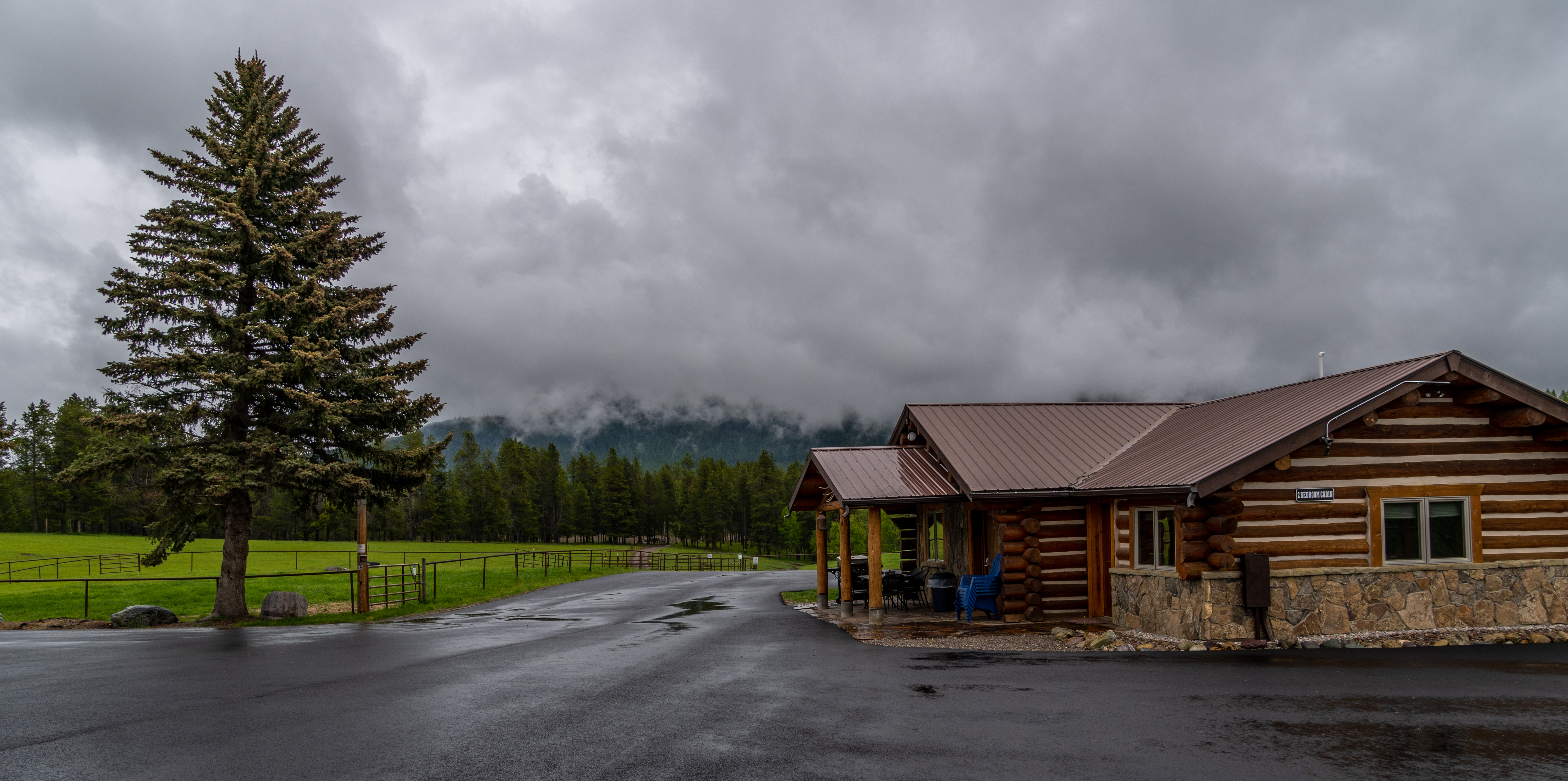
There were two large shared baths and all of us were mindful of being quiet and keeping the bathrooms clean. I think probably we were all so quiet because we were exhausted from exploring the park all day, every day. Our rooms didn’t have kitchens, but there was a large covered patio at the end of the building with three picnic tables, three big gas grills and two microwaves. They’ve left one very tall pressure-treated pole on the property for their resident wood pecker to bang away at, thus leaving the other buildings intact. From the sound of it, we were surprised that his beak wasn’t crumpled!

The next two days were spent on the West side of the park along that end of the Going-to-the-Sun Road. We learned that, because they were still clearing snow, only 8-miles of the West Road were accessible to Avalanche Creek, and only two miles of the road, to Rising Sun, on the East Road. There’s an endless number of stopping points along Lake McDonald on the West Road, providing infinite opportunities for photos of the majestic peaks and breathtaking beauty.


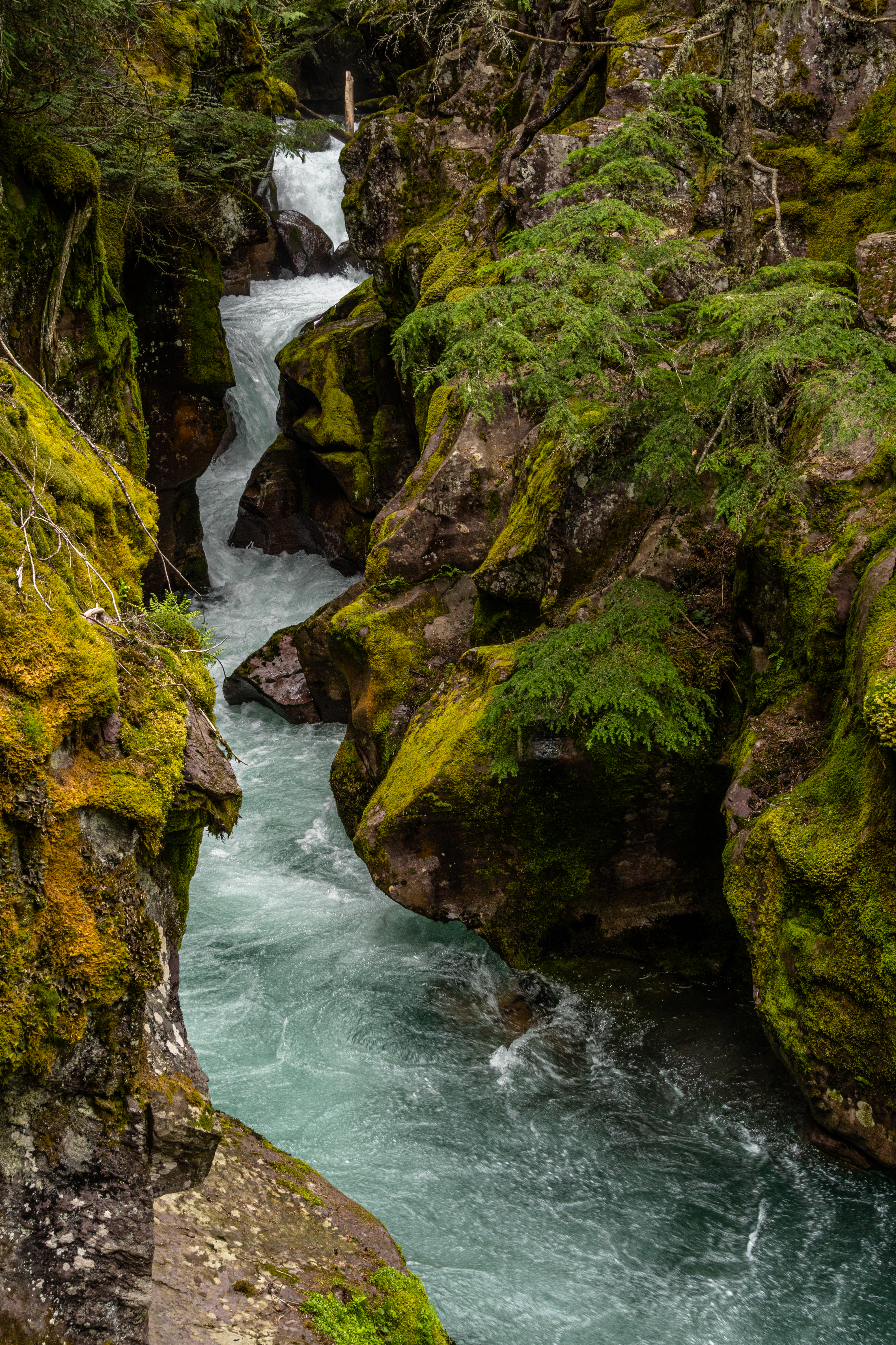
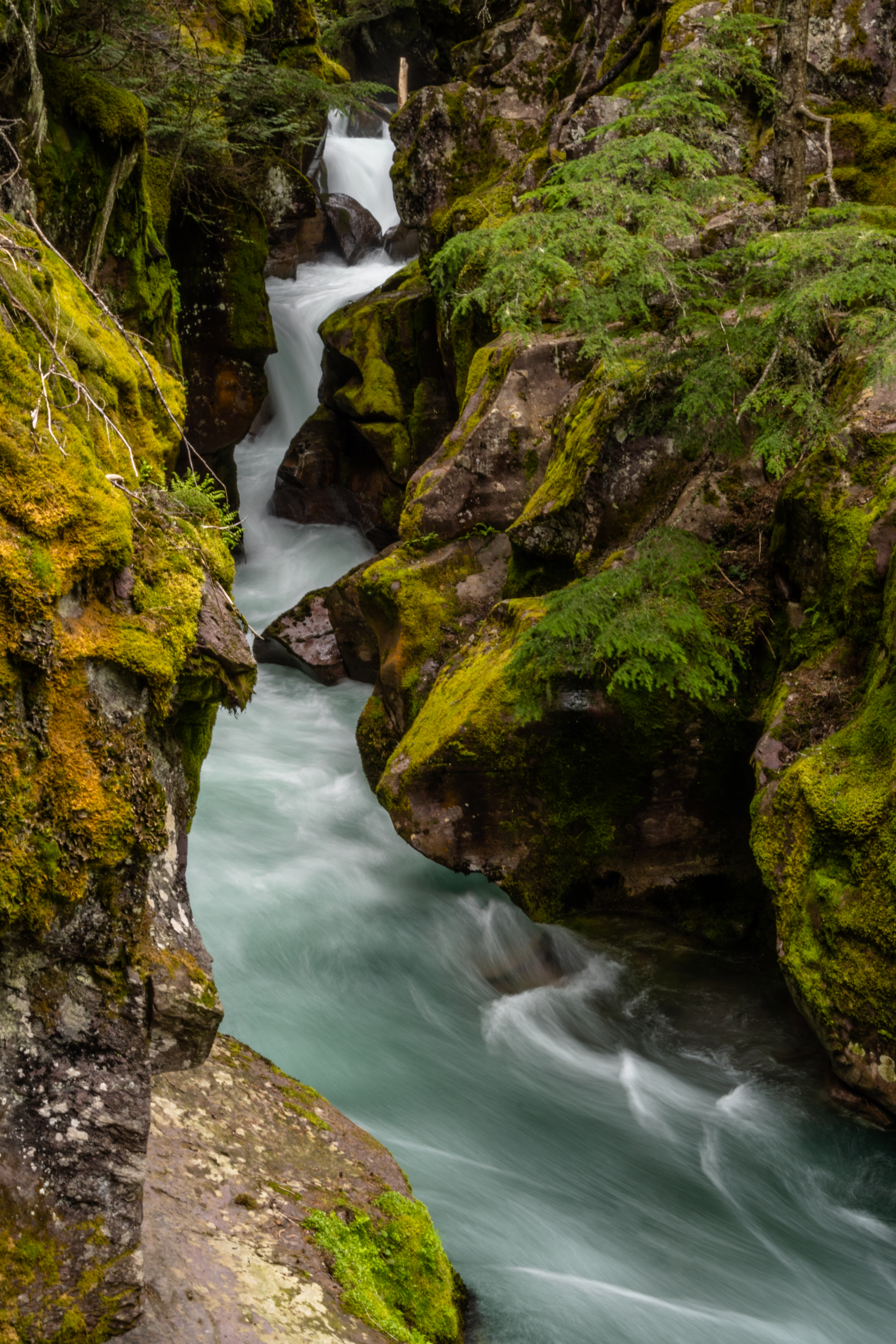
The Trail of the Cedars at Avalanche Lake is an easy walk along the river with a waterfall gouging its way through narrow canyon walls. We hiked part of the more strenuous Avalanche Lake trail, stopping to catch sight of a grizzly bear high up on a wooded hillside (pictured above), relaxing behind a big rock and some downed trees, peeking out at all of us onlookers. Bear spray at the ready? Check.

The next day we sucked it up and hiked all the way to Avalanche Lake. Awe-inspiring may not do this scene justice as the mountains rise right up from the far edge of the lake, reflecting in the placid glacial water. With binoculars, many of us were able to watch a mother grizzly and two cubs making their way high up along a rocky mountainside on the other side of the river.


Afterward, we hiked one of the Johns Lake trails, one of the places we were glad to have bear spray. For a time, we thought we’d lost the trail, but joining up with another group who’d thought the same, we all made it out to the road where they’d left their cars, and we crossed to continue on, finally making it past Johns Lake and back to our car at Lake McDonald falls.
The forecast rain had so far happened mostly at night and the days were perfect. The fourth day we awoke to low-hanging fog and, when you could see it, gray sky. We returned to the East side and the weather was clear, while it rained all day to the West. By now we had more info and knew that we just had to keep driving on Rt 49 to reach the Saint Mary entrance to the Going-to-the-Sun Road, 2-hrs north of Two Medicine. We were able to park at the Rising Sun Visitor Center and then, those who were able, could walk or ride their bikes about two miles further in. We took our time to enjoy the scenery, taking some unnamed trail down to Saint Mary Lake. We would have never noticed it had someone else not been climbing over the road barrier. I think that’s how everyone found it, by seeing someone else enter or exit.

Another 30-minutes north of St. Mary we finally made it to Many Glacier. At least one other glacier and other named sites would have been visible from the middle section of the Going-to-the-Sun Road, but it was still impassible. After maybe 2-3 miles of paved road, there’s 15-miles of gravel road to the Many Glacier Visitor Center. As we all know, the world’s glaciers have been receding for a long time, and I had heard that you have to drive or hike quite a way to see them. “See” them is only with binoculars and, really, you could be looking at any large plane of ice or snow and think you’re looking at a glacier. Without a road-side diorama, you’d never know what you were looking at.


That evening, one of the other Homestead guests told us that the glaciers are more striking later in the year when much of the snow has melted, allowing the glaciers to stand out more. So yeah, that part was underwhelming, but it didn’t take away from the beauty of Lake Sherburne or the (moderate on the map but difficult for us) hike to Apikuni Falls, one of the many falls in the area. The highlight of that hike was the large bull moose that was grazing at the bottom of the trail. Traveling back along the gravel road we and a few other cars spied a couple of grizzlies making their way through the brush not too far up a hillside, then we saw a couple of big-horn sheep, too.

Our last day was spent doing laundry in town and relaxing. Steve got the OK from the owner to take a walk on the trail through the pastures towards the mountains, but he only went as far as the pond over the ridge. Like the Pied Piper, on his way back, two horses and several mules followed him to the gate. Later as the rain returned, we grilled corn-on-the-cob and warmed some pre-cooked sausage from a local deli for supper.


There is so much more to see in the northernmost sections of the park and within British Colombia, however, the East side BC entrance was closed and it was a very long way north and east before the road would turn west and back to the park. The same was true for the West side above Polebridge. Though it was tempting to drive all the way to Polebridge, we’d heard the gravel roads weren’t in great shape. After already replacing two tires, we weren’t in any hurry to tempt fate.
Mostly satisfied with all that we had seen and done, it was time to get on the road toward Michigan where we would be spending almost two-weeks with friends and then six-weeks near Detroit for the final house sit of our grand adventure that began last October.


Always enjoy your adventures. Wonderful images, too.
LikeLike
Lovely photos…sounds like you are enjoying the outdoors~ Linda * *Linda Sorrento
LikeLike